Welcome to Newton
Settled in 1630, Newton, Massachusetts is a vibrant community comprised of 13 distinctive villages.
Located just outside of Boston, Newton is well respected for the quality of education, community life, exceptional homes, and beautiful open spaces. Newton has frequently been voted as one of the 10 best communities to live in.
With approximately 26,000 homes, the City also houses Boston College, UMass Amherst at Mt. Ida Campus and Lasell College. The Boston Marathon runs right through the City with Heartbreak Hill beginning next to City Hall. The Newton Free Library is well respected as one of the largest, most well equipped libraries in the Commonwealth.
Key Details
Settled - 1630
Incorporated - 1688
County - Middlesex
Zip code - 02458–02462, 02464–02468, 02495
Area
Total - 18.2 sq mi (47.1 km2)
Land - 18.1 sq mi (46.7 km2)
Water - 0.2 sq mi (0.4 km2)
Population (2010)
Total - 85,146
Density - 4,700/sq mi (1,800/km2)
Resources
-
Newton was settled in 1630 as part of "the newe towne", which was renamed Cambridge in 1638. Roxbury minister John Eliot convinced the Native American people of Nonantum, a sub-tribe of the Massachusett led by a sachem named Waban, to relocate to Natick in 1651, fearing that they would be exploited by colonists. Newton was incorporated as a separate town, known as Cambridge Village, in 1688, then renamed Newtown in 1691, and finally Newton in 1766. It became a city in 1873. Newton is known as The Garden City.
In Reflections in Bullough's Pond, Newton historian Diana Muir describes the early industries that developed in the late 18th and early 19th centuries in a series of mills built to take advantage of the water power available at Newton Upper Falls and Newton Lower Falls. Snuff, chocolate, glue, paper and other products were produced in these small mills but, according to Muir, the water power available in Newton was not sufficient to turn Newton into a manufacturing city, although it was, beginning in 1902, the home of the Stanley Motor Carriage Company, the maker of the Stanley Steamer.
Newton, according to Muir, became one of America's earliest commuter suburbs. The Boston and Worcester, one of America's earliest railroads, reached West Newton in 1834. Wealthy Bostonian businessmen took advantage of the new commuting opportunity offered by the railroad, building gracious homes on erstwhile farmland of West Newton hill and on Commonwealth street. Muir points out that these early commuters needed sufficient wealth to employ a groom and keep horses, to drive them from their hilltop homes to the station.
Further suburbanization came in waves. One wave began with the streetcar lines that made many parts of Newton accessible for commuters in the late nineteenth century. The next wave came in the 1920s when automobiles became affordable to a growing upper middle class. Even then, however, Oak Hill continued to be farmed, mostly market gardening, until the prosperity of the 1950s made all of Newton more densely settled. Newton is not a typical "commuter suburb" since many people who live in Newton do not work in downtown Boston. Most Newtonites work in Newton and other surrounding cities and towns.
The city has two symphony orchestras, the New Philharmonia Orchestra of Massachusetts and the Newton Symphony Orchestra.
Each April on Patriots Day, the Boston Marathon is run through the city, entering from Wellesley on Route 16 (Washington Street) where runners encounter the first of the four infamous Newton Hills. It then turns right onto Route 30 (Commonwealth Avenue) for the long haul into Boston. There are two more hills before reaching Centre Street, and then the fourth and most infamous of all, Heartbreak Hill, rises shortly after Centre Street. Residents and visitors line the race route along Washington Street and Commonwealth Avenue to cheer the runners.
-
Crystal Lake is a 33-acre (130,000 m2) natural lake located in Newton Centre. Its shores, mostly lined with private homes, also host two small parks, a designated swimming area, and a bath house. The public is not allowed to swim outside of the small swimming area. The name Crystal Lake was given to the pond by a nineteenth-century commercial ice harvester that sold ice cut from the pond in winter. It had previously been called Baptist Pond.
The Jackson Homestead, now the Newton History Museum at the Jackson Homestead, is best known for its history as a stop on the Underground Railroad. It was built in 1809 as a farmhouse designed in the Federal style, and is now a museum with paintings, costumes, photographs, manuscripts, maps and historical artifacts.
Heartbreak Hill, notably challenging stretch of the Boston Marathon, on Commonwealth Avenue between Centre Street and Boston College.
Newton is home to many exclusive golf courses such as Woodland Country Club, Charles River Country Club, and Brae Burn Country Club, which held the United States Open in 1919.
City Stable and Garage, historic building
The John A. Fenno House is a historic house at 171 Lowell Avenue, built c. 1854, and a rare local example of Gothic Revival styling.
The House at 173-175 Ward Street is one of the city's few Federal style houses, built c. 1800,
Echo Bridge is a notable 19th-century masonry arch bridge with views of the river and Hemlock Gorge in Hemlock Gorge Reservation just off Route 9 in Newton Upper Falls.
Norumbega Park was located in Auburndale on the Charles River. Opening in 1897 as a trolley park, it was a popular amusement park through the 1950s before closing in 1963. Its Totem Pole Ballroom became a well-known dancing and entertainment venue for big bands touring during the 1940s. The park is now a popular dog-walking site with hills, meadows, woods, and access to the river.
Chestnut Hill Reservoir
Auburndale Cove is a multipurpose picnic and recreational area on the Charles River just down the walking path from Norumbega Park.
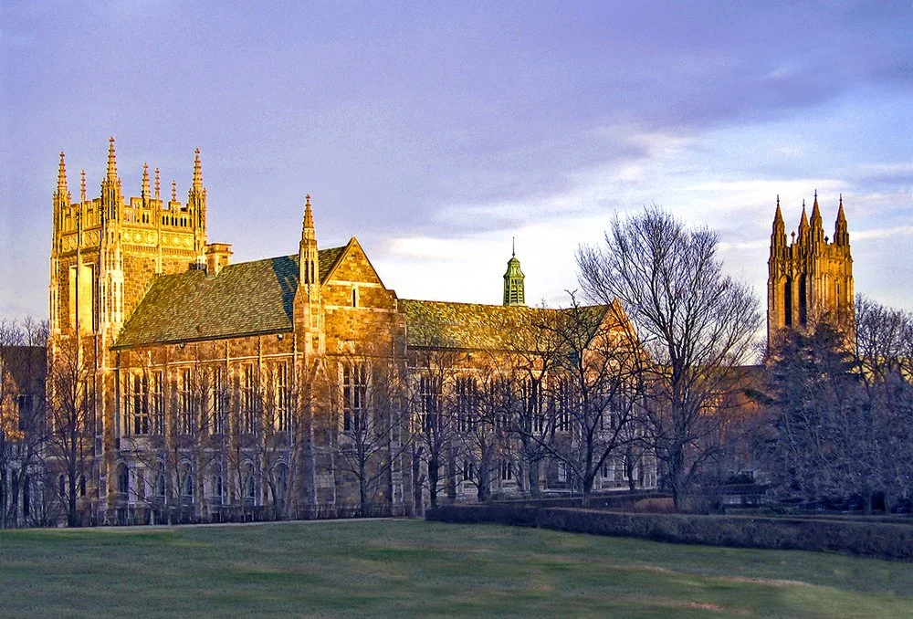
Chestnut Hill Reservoir is a very popular park with residents of Newton, Brookline, and the Brighton section of Boston. Although completely within the Boston city limits, it is directly contiguous to the Newton city limits. Designed by Frederick Law Olmsted, the designer of Central Park in New York City and the Emerald Necklace in Boston, the park offers beautiful views of the Boston skyline, and is framed by stately homes and the campus of Boston College. Although not generally used to supply water to Boston, the reservoir was temporarily brought back online on May 1, 2010, during a failure of a connecting pipe at the end of the MetroWest Water Supply Tunnel.
Bullough's Pond is an old mill pond transformed into a landscape feature when Newton became a suburban community in the late nineteenth century. It has been the subject of two books, Reflections in Bullough's Pond: Economy and Ecosystem in New England, by Diana Muir, and Once Around Bullough's Pond: A Native American Epic, by Douglas Worth. It was long maintained by the city as an ice skating venue, but skating is no longer allowed. A scene from the 2008 remake of The Women was filmed there.
The city of Newton has designated several roads in the city as "scenic". Along with this designation come regulations aimed at curbing tree removal and trimming along the roads, as well as stemming the removal of historic stone walls. The city designated the following as scenic roads: Hobart Rd., Waban Ave., Sumner St., Chestnut St., Concord St., Dudley Rd., Fuller St., Hammond St., Valentine St., Lake Ave., Highland St., and Brookside Ave.
The First Baptist Church in Newton Centre, built in 1888, was designed by John Lyman Faxon in the Richardsonian Romanesque style pioneered by architect Henry Hobson Richardson.
The WHDH-TV tower is one of the tallest free-standing lattice towers in USA.
-
Elementary Schools
Angier Elementary School
Bowen Elementary School
Burr Elementary School
Cabot Elementary School
Countryside Elementary School
Franklin Elementary School
Horace Mann Elementary School
Lincoln Eliot Elementary School
Mason Rice Elementary School
Memorial Spaulding Elementary School
Peirce Elementary School
Underwood Elementary School
Ward Elementary School
Williams Elementary School
Zervas Elementary School
Middle Schools
Bigelow Middle School
Brown Middle School
Oak Hill Middle School
F.A. Day Middle School
High Schools
Newton North High School
Newton South High School
Private Schools
Fessenden School is a K–9-day and 5–9 boarding school for boys.
Jackson School is a private, Catholic elementary school sponsored by the Sisters of Saint Joseph of Boston.
Newton Country Day School
Solomon Schechter Day School of Greater Boston is a K–8 Conservative Jewish day school.
Newton Montessori School is a K-6 private elementary school.
Mount Alvernia High School is a private girls' school for grades 7–12.
Mount Alvernia Academy is an independent Catholic School for Preschool through Grade 6.
Higher Education
Boston College in Chestnut Hill
Boston College Law School in Newton Centre
Hebrew College in Newton Centre
Lasell College in Auburndale
William James College, formerly Massachusetts School of Professional Psychology in Newton Upper Falls

Location

Newton Market Statistics


Check out other communities we service
Boston Neighborhoods
Back Bay, South End, Downtown, Fenway, South Boston, Seaport, East Boston, Allston, Brighton, Jamaica Plain, West Roxbury, Roslindale
North Shore
Swampscott, Marblehead, Salem, Peabody, Lynnfield, Wakefield, Reading, North Reading, Middleton, Danvers, Beverly, Manchester by the Sea, Gloucester, Rockport, Essex, Ipswich, Hamilton, Wenham, Topsfield, Boxford, North Andover, Andover
North of Boston
Cambridge, Somerville, Winchester, Medford, Malden, Melrose, Stoneham, Woburn, Saugus, Arlington, Lexington, Belmont, Burlington, Wilmington
West of Boston (Metrowest)
Brookline, Newton, Weston, Wellesley, Sudbury, Wayland, Lincoln, Waltham, Watertown, Dedham, Needham, Sudbury, Framingham, Natick, Westborough, Southborough, Marlborough, Hudson, Ashland, Dover
*content on this page is a mixture of original and pulled from multiple locations including Wikepedia