Welcome to Brookline
Brookline is primarily a mature suburban, residential community with urban characteristics. The primary occupations of Brookline residents are management and professional, heavily concentrated in the fields of medicine and education.
The Town of Brookline continues to be a safe and highly desirable place to live, due to its proximity to job opportunities, excellent public transportation and school systems, and livable neighborhoods that balance green space, historic preservation, and outstanding commercial services. Surrounded by the City of Boston on three sides, Brookline consists of roughly six square miles of land.
The Town, which began as an agricultural community in the 17th century, became a streetcar suburb of Boston during the mid-19th century. By 1900, most of the remaining farmland had been divided into residential developments that were supported by the existing mass transit linkages. Brookline’s transformation from farm to suburb meant that, unlike many other Massachusetts towns, it never had significant industrial areas. Currently less than 6% of Town land is zoned for commercial use.
Key Details
Settled - 1638
Incorporated - 1705
County - Norfolk
Zip code - 02445, 02446, 02467
Area
Total - 6.8 sq mi (17.7 km2)
Land - 6.89 sq mi (17.6 km2)
Water - 0.01 sq mi (0.1 km2)
Population (2010)
Total - 58,732
Density - 8,637.0/sq mi (3,337.0/km2)
Resources
-
Once part of Algonquian territory, Brookline was first settled by European colonists in the early 17th century. The area was an outlying part of the colonial settlement of Boston and known as the hamlet of Muddy River. In 1705, it was incorporated as the independent town of Brookline. The northern and southern borders of the town were marked by two small rivers or brooks, hence the name. The northern border with Brighton (which was itself part of Cambridge until 1807) was Smelt Brook. (That name appears on maps starting at least as early as 1852, but sometime between 1888 and 1925 the brook was covered over. The southern boundary, abutting Boston, was the Muddy River.
The Town of Brighton was merged with Boston in 1874, and the Boston-Brookline border was redrawn to connect the new Back Bay neighborhood with Allston-Brighton. This merger created a narrow strip of land along the Charles River belonging to Boston, cutting Brookline off from the shoreline. It also put certain lands north of the Muddy River on the Boston side, including what are now Kenmore Square and Packard's Corner. The current northern border follows Commonwealth Avenue, and on the northeast, St. Mary's Street. When Frederick Law Olmsted designed the Emerald Necklace of parks and parkways for Boston in the 1890s, the Muddy River was integrated into the Riverway and Olmsted Park, creating parkland accessible by both Boston and Brookline residents.
Throughout its history, Brookline has resisted being annexed by Boston, in particular during the Boston–Brookline annexation debate of 1873. The neighboring towns of West Roxbury and Hyde Park connected Brookline to the rest of Norfolk County until they were annexed by Boston in 1874 and 1912, respectively, putting them in Suffolk County. Brookline is now separated from the remainder of Norfolk County.
Brookline has long been regarded as a pleasant and verdant environment. In 1841 edition of the Theory and Practice of Landscape Gardening, Andrew Jackson Downing described the area this way:
'The whole of this neighborhood of Brookline is a kind of landscape garden, and there is nothing in America of the sort, so inexpressibly charming as the lanes which lead from one cottage, or villa, to another. No animals are allowed to run at large, and the open gates, with tempting vistas and glimpses under the pendent boughs, give it quite an Arcadian air of rural freedom and enjoyment. These lanes are clothed with a profusion of trees and wild shrubbery, often almost to the carriage tracks, and curve and wind about, in a manner quite bewildering to the stranger who attempts to thread them alone; and there are more hints here for the lover of the picturesque in lanes than we ever saw assembled together in so small a compass.'
Brookline residents were among the first in the country to propose extending the vote to women. Benjamin F. Butler, in his 1882 campaign for Governor, advocated the idea.
Two branches of upper Boston Post Road, established in the 1670s, passed through Brookline. Brookline Village was the original center of retail activity.[5] In 1810, the Boston and Worcester Turnpike, now Massachusetts Route 9, was laid out, starting on Huntington Avenue in Boston and passing through the village center on its way west.
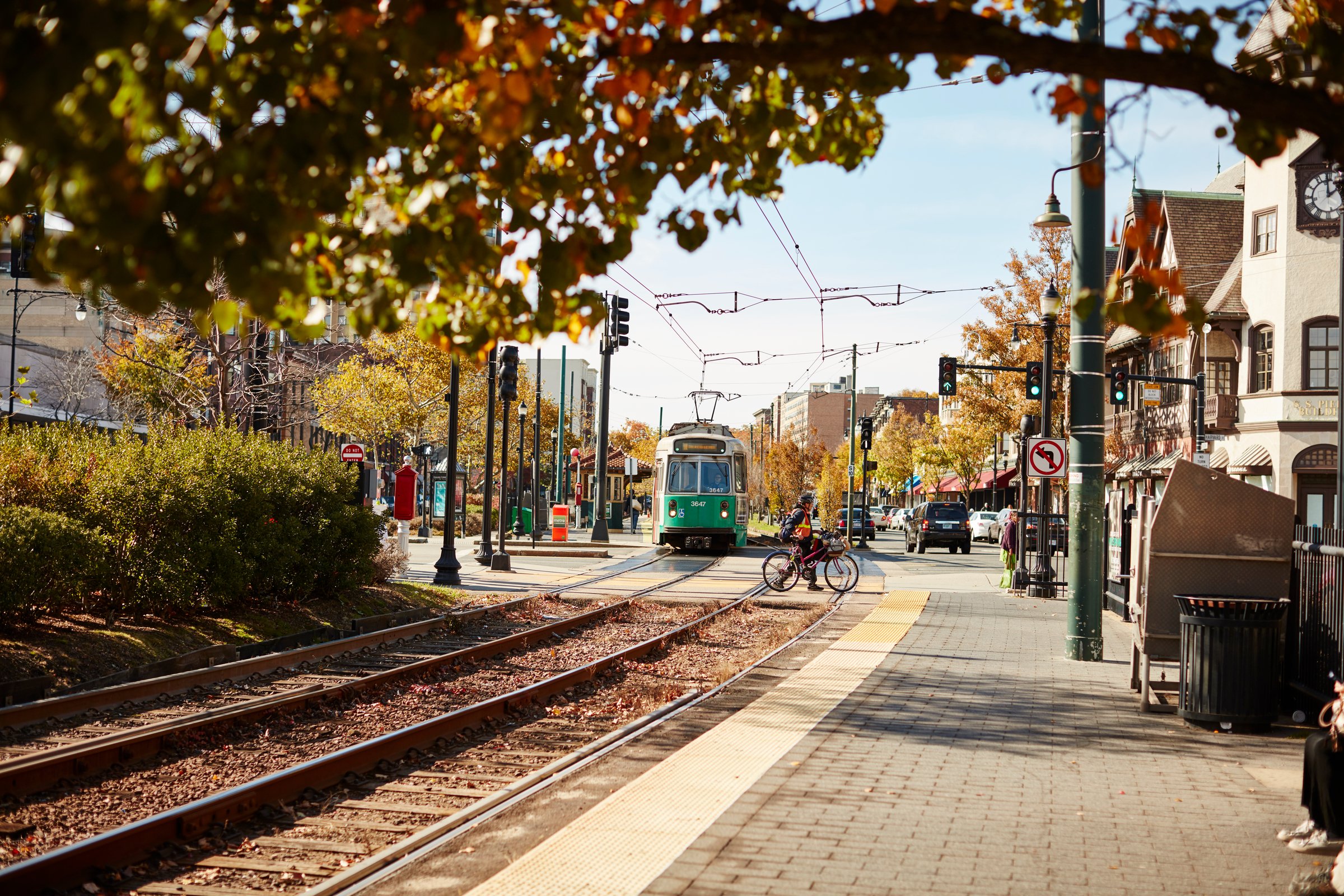
Steam railroads came to Brookline in the middle of the 19th century. The Boston and Worcester Railroad was constructed in the early 1830s, and passed through Brookline near the Charles River. The rail line is still in active use, now paralleled by the Massachusetts Turnpike. The Highland Branch of the Boston and Albany Railroad was built from Kenmore Square to Brookline Village in 1847, and was extended into Newton in 1852. In the late 1950s, this would become the Green Line "D" Branch.
The portion of Beacon Street west of Kenmore Square was laid out in 1850. Streetcar tracks were laid above ground on Beacon Street in 1888, from Coolidge Corner to Massachusetts Avenue in Boston, via Kenmore Square. In 1889, they were electrified and extended over the Brighton border at Cleveland Circle. They would eventually become the Green Line "C" Branch.
Thanks to the Boston Elevated Railway system, this upgrade from horse-drawn carriage to electric trolleys occurred on many major streets all over the region, and made transportation into downtown Boston faster and cheaper. Much of Brookline was developed into a streetcar suburb, with large brick apartment buildings sprouting up along the new streetcar lines.
Brookline was known as the hamlet of Muddy River and was considered part of Boston until the Town of Brookline was independently incorporated in 1705. (The Muddy River was used as the Brookline–Boston border at incorporation.) It is said that the name derives from a farm therein once owned by Judge Samuel Sewall.
-
Coolidge Corner, which is located at the crossing of Beacon Street and Harvard Street, is one of Brookline's two primary retail districts (the other being Washington Square). It includes a number of historically significant sites, including the S.S. Pierce Building, and the Coolidge Corner Theatre.
There were two stops on the Underground Railroad in Brookline: 9 Toxteth Street and 182 Walnut Street
The Country Club, an exclusive sporting club in the town, was the first private club in the United States formed exclusively for outdoor activities. It is most famous as a golf club; it was one of the five clubs that formed what is now the United States Golf Association and has hosted the U.S. Open three times and the Ryder Cup Matches once.
"Fairsted", the 100-year-old business headquarters and design office for renowned landscape architect Frederick Law Olmsted and the Olmsted Brothers firm, has been carefully preserved as the Frederick Law Olmsted National Historic Site, on 7 acres (2.8 ha) of landscaped grounds at 99 Warren Street.
Brookline is home to part of Frederick Law Olmsted's Emerald Necklace of park systems, including Olmsted Park.
Larz Anderson Park is in Brookline on the 64-acre (26 ha) estate once owned by Larz Anderson and Isabel Weld Perkins. The park contains the Larz Anderson Auto Museum, the oldest automobile collection in the country, as well as Putterham School, a one-room schoolhouse from colonial times.
The birthplace of John F. Kennedy stands in Brookline and is listed in the National Register of Historic Places. It is maintained by the National Park Service and is open to the public from May through September.
St. Aidan's Church was where John F. Kennedy was baptized and where the Kennedy family and other prominent Irish-Americans were parishioners. The church was designed by architect Charles Maginnis, who was awarded the American Institute of Architects' gold medal. Although it is listed on the National Register of Historic Places, St. Aidan's Church has been closed and converted into housing.
The Puppet Showplace Theatre, one of the four oldest puppet theatres in the United States, is located in Brookline Village.
The Dutch House, one of only five surviving buildings from the World's Columbian Exposition of 1893 was relocated to Brookline.
John Goddard House, an historic house at 235 Goddard Avenue, was built in 1767 and added to the National Register of Historic Places in 1985.
-
Public schools
The student body at Brookline High School includes students from more than 50 countries. Many students attend Brookline High from surrounding neighborhoods in Boston such as Mission Hill and Mattapan through the Metropolitan Council for Educational Opportunity (METCO) system.
There are eight elementary schools in the Brookline Public School system: Baker School, Coolidge Corner School, Driscoll, Heath, Lawrence, Lincoln, Pierce, and Runkle. The system includes one early learning center, eight grades K-8 schools, and one comprehensive high school. The Old Lincoln School is a surplus building used by the town to temporarily teach students in when another school building is being renovated.
Private schools
Beaver Country Day School
Brimmer and May School - partly in Newton
Dexter Southfield School
Ivy Street School
Maimonides School
The Park School
Higher Education
Pine Manor College
Hellenic College
Newbury College
Holy Cross Greek Orthodox School of Theology
parts of Boston University
parts of Boston College
part of the Wheelock College campus
Northeastern University's Parsons Field
Boston Graduate School of Psychoanalysis

Properties on Market in Brookline
Location

Brookline borders Newton (part of Middlesex County) to the west and Boston (part of Suffolk County) in all other directions; it is therefore non-contiguous with any other part of Norfolk County.
Brookline Market Statistics


Check out other communities we service
Boston Neighborhoods
Back Bay, South End, Downtown, Fenway, South Boston, Seaport, East Boston, Allston, Brighton, Jamaica Plain, West Roxbury, Roslindale
North Shore
Swampscott, Marblehead, Salem, Peabody, Lynnfield, Wakefield, Reading, North Reading, Middleton, Danvers, Beverly, Manchester by the Sea, Gloucester, Rockport, Essex, Ipswich, Hamilton, Wenham, Topsfield, Boxford, North Andover, Andover
North of Boston
Cambridge, Somerville, Winchester, Medford, Malden, Melrose, Stoneham, Woburn, Saugus, Arlington, Lexington, Belmont, Burlington, Wilmington
West of Boston (Metrowest)
Brookline, Newton, Weston, Wellesley, Sudbury, Wayland, Lincoln, Waltham, Watertown, Dedham, Needham, Sudbury, Framingham, Natick, Westborough, Southborough, Marlborough, Hudson, Ashland, Dover
*content on this page is a mixture of original and pulled from multiple locations including Wikepedia